You may notice that the stream is now on the left of the track. It passed beneath our feet via a culvert.
Looking back, just behind the the mounds are the remains of the entrance to Oakwood Mill Land Level, an iron ore mine.
The land level was driven from 365 feet O.D. at the entrance. It is an adit or tunnel driven into the hill side for a distance of 1650 feet (500 metres). From the far end of the tunnel further levels were driven at right angles to facilitate mining and removal of the iron ore. The level also allowed water to drain from the iron ore measures above 365 feet, allowing previously underwater deposits to be exploited. The level can be seen on Sopwith’s map of 1835.
In 1827 David Mushet the metallurgist laid the Oakwood tramroad from here to Parkend.
Within a short distance you can observe a series of large flat stones in the pathway. These are sleepers for the Oakwood Tramway which terminated at Parkend and was used to transport mainly iron ore for transfer to the railway at Marsh Sidings (near Parkend’s Fountain Inn).
Also further on, to the left of the path, we come to site that was once the location of Oakwood Foundry. The Keystone from the Foundry is in a local garden and is dated 1852.

In the 1950’s the main foundry building was still standing and was used as a residence by the Carson family. The living conditions in this 3 storey building would have to be considered grim, even by the standards of the time.

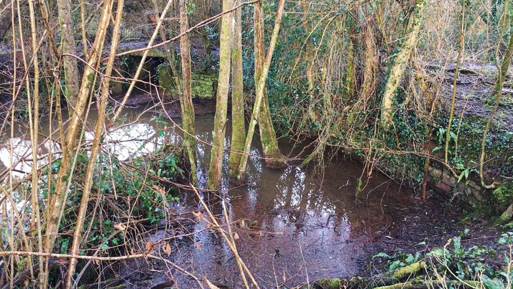
Finally, to the left and right of the track are the remains of the mill ponds which fed the water wheel at the Oakwood Corn Mill. The mill occupied the old buildings to the left and the waterwheel which drove the machinery was situated in a sunken chamber at the side. The sluice gate, which released the water onto the wheel, can be seen in the far corner of the stone-lined pond. It is probable that the operation of the mill was sporadic and dependant on the mill ponds containing sufficient water to drive the wheel.
With its hilly terrain, this is not an obvious location for a flour mill since most of the arable farms were on land cleared of trees on the opposite side of the village. Unluckily for the farmers of that area it is devoid of streams of a size capable of supplying water in sufficient quantities for a mill to operate. The Gloucestershire Way that we will soon join uses an old track that connects the Mill with the farmland. Oakwood Mill was so important that it was made a detached part of the parish of Newland and remained so until Bream became a parish, a right it won in 1856.